China Constructs New Road Links To Ladakh On Stretch That Sparked 1962 War
By Col Vinayak Bhat
27 August, 2020
China’s road network in Tibet has always been a military asset, and now new construction of laterals providing alternate routes to the existing roads in areas bordering Ladakh is happening at a fast pace. This will shorten the duration and facilitate quicker troop mobilisation for the Chinese People’s Liberation Army (PLA).
Satellite images studied over the last decade indicate that the PLA has been preparing new laterals north-east of Eastern Ladakh. This includes a lateral to the National Highway 219 (G219) from Lhasa to Kashgar. The road passing through areas of Eastern Ladakh was noticed in the mid 1950s and completed by 1957. The construction of the road was the beginning of the tension between India and China that eventually led to the 1962 war.
The areas west of the new road G219 were occupied by China after the war. The Chinese War Memorial on the G219 stands as a reminder of how the Indian Army although outnumbered fought very bravely in this area.
Since then, road building and infrastructure activity by both sides close to the Line of Actual Control have been viewed with suspicion by the two countries. One of the reasons that sparked the current tussle in Ladakh was India’s road construction.
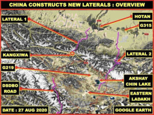
Laterals Between G219 And G315
The terrain being extremely difficult, the only road G219 to Eastern Ladakh would be difficult for the PLA to use for maintenance of its troops during a conflict, especially if airpower is used by India.
The PLA seems to have understood the importance of laterals in mountainous areas that are vulnerable to natural incidents such as landslides, sudden floods as also to the adversary’s aerial threats like bombing and shelling.
These laterals could be used effectively for switching of forces and sending in reinforcements into the contested areas of Eastern Ladakh during any emergencies. They would also change the logistics support to the PLA in this area and would in turn change the complete dynamics of Indian operational plans.
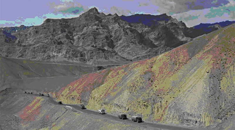
The PLA has carried out multiple military exercises to try out these routes for military movement in the last two years. China has completed the construction of the first lateral between Hotan and Kangxiwa, now named the G580 Provincial Highway.
The road is on average 10m wide and 190km long. There is only a single place where the road crosses over mountain pass at 5,200m height. A number of locations along the road have been prepared for the PLA columns for transit to stay along this route.
The route reduces the distance between Hotan and Eastern Ladakh’s entry point Haji Langar by almost 400km.
The second lateral starts about 100km east of Hotan and ends below the Akshai Chin Lake with an average width of 10m and length of almost 345km. The road is not yet complete but hectic construction activities are observed along this route at various places.
The road passes over two mountains passes at 5,500m and at 6,030m. This road would reduce the distance as well as create redundancy for laterals.
China‘s Occupation Of Eastern Ladakh In 1950s
China occupied parts of Eastern Ladakh in the 1950s when they wanted to build a road to East Turkestan from Tibet.
The road construction was noticed first by some Indian scientists who were experimenting on the feasibility of various salts from the endorheic basin lake called Akshai Chin (White Deserts), also known for a lake that never dries.
The presence of the Chinese army was noticed and reported. However, on inquiry, the Chinese claimed that it was basically to carry out astronomical research and India does not have anything to worry about.
Since the area was very remote and did not have any permanent presence of the Indian Army, the area was patrolled on the possible biannual frequency with long-range patrols (LRP).
Indian General Zorawar Singh under Dogra ruler Maharaj Gulab Singh conquered the areas beyond Eastern Ladakh and sent his forces through the valleys of mighty Karakoram ranges towards Khotan (Hotan), Yarkhand and Kashgar.
The campaign had to be cut short as the attention was paid to Tibetan forces getting together in southeast of Eastern Ladakh. His forces had conquered areas right up to Central Tibet, including Taklakot and beyond.
The routes taken by Zorawar Singh’s forces seem to have been studied by the Chinese researchers very deeply and recently that knowledge has been applied by engineers to construct laterals between the G219 and G315 national highways.
(Col Vinayak Bhat (Retd) is a consultant for India Today. A satellite imagery analyst, he served in the Indian Army for over 33 years)
Courtesy: Opera News/India Today