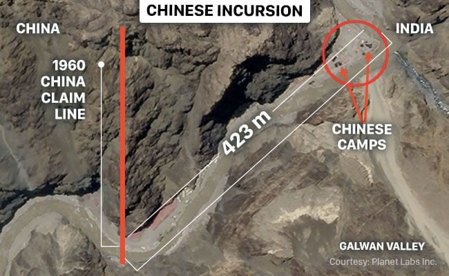
China Intrudes 423 Metres Into Indian Territory In Galwan
29 June, 2020
High resolution satellite images procured by NDTV indicate that as of June 25, there were 16 Chinese tents and tarpaulins, one large shelter and at least 14 vehicles in this 423 metre stretch of Indian territory.
New Delhi:
China’s forces in the Galwan Valley have intruded 423 metres into Indian territory, an incursion which seems to be well ahead of Beijing’s own 1960 Claim Line in the region.
High resolution satellite images procured by NDTV indicate that as of June 25, there were 16 Chinese tents and tarpaulins, one large shelter and at least 14 vehicles in this 423 metre stretch of Indian territory.
The Chinese claim of 1960 including the exact latitude and longitude of what Beijing believed to be its boundary in this area has been spelt out in ”Report of the Officials of the Governments of India and the People’s Republic of China on the Boundary Question.”
The document, published by the Ministry of External Affairs in 1960-1961, lists Indian questions and the Chinese responses in talks held between the two sides. In response to an Indian question on the height of some peaks and location of specific passes, the Chinese side lists a series of specific coordinates of their claim, including in the Galwan river area. According to this, ”after the alignment passed over the two peaks, it went south along the mountain ridge, where it crossed the Galwan river at Long. 78° 13′ E, Lat. 34° 46′ N.”
A simple search of these coordinates on Google Earth Pro indicates the precise location of this line in the Galwan Valley. The areas to the immediate north of these coordinates should be Indian territory. Instead, as the satellite pictures indicate, there is a clear incursion here. The measurement tool on Google Earth Pro indicates that the Chinese are in occupation of 423
”They are taking a very maximalist position,” says former Foreign Secretary Nirupama Rao who was privy to boundary talks between India and China during her tenure. ”They are going far beyond their definition of their claim line as conveyed to us in the official talks.”
In his address to the nation yesterday on his monthly radio show, “Mann Ki Baat”, Prime Minister Narendra Modi said, without naming China, “Those who cast an evil eye on Indian soil in Ladakh have got a befitting response. India honours the spirit of friendship. She is also capable of giving an appropriate response to any adversary, without shying away.” On June 27, Vikram Mistry, India’s Ambassador to Beijing said, “The resolution of this issue is quite straight forward from our perspective. The Chinese side needs to stop creating obstruction and hindrances in the normal patrolling patterns of the Indian troops.”
Towards the end of October 1962, the Chinese People’s Liberation Army had reached their 1960 claim line in this sector after intense battles with the Indian Army deployed in the Galwan region. Following the announcement of a unilateral ceasefire by the Chinese in November 1962, the Chinese withdrew from this area. For decades, patrols by both Indian and Chinese forces here have been few and far between and it is believed that discussions on the alignment of the Line of Actual Control in Galwan did not feature in talks in the early nineties when New Delhi and Beijing met to discuss the LAC.
On June 15, in the worst fighting between Indian and Chinese forces in 53 years, 20 Indian soldiers were killed in action here including a Colonel. Army sources say that as many as 45 Chinese soldiers, including a Colonel were also killed. The fighting is believed to have taken place not just on the Chinese-occupied embankment located at a crucial bend of the Galwan river but also at Patrol Point 14, a spot on the Line of Actual Control which marks the extent of the Indian Army’s traditional patrolling routes in this area. Patrol Point 14 is believed to be along the ridge line broadly overlooking the bend of the Galwan River. Several soldiers, both Indian and Chinese are believed to have fallen off the ridge to their deaths in the fighting that took place on June 15.
”What has happened in Galwan could well be a reflection of things to come in other areas along the LAC where the Chinese are seeking to impose new interpretations of the LAC,” says Ms Rao. Reports indicate that China has already made major incursions in the Fingers region of the Pangong Lake in Ladakh and may be attempting to close in to the area near the Indian Air Force’s air strip at Daulat Beg Oldie near the Karakoram Pass to the north.
The Chinese incursion in Galwan and continued construction activity in Indian territory clearly indicate that China may have no immediate plans to vacate the area. In fact, satellite images of Galwan clearly indicate a consolidation of Chinese positions in Galwan, both within Indian territory and on their side of the Line of Actual Control. This includes broadening of the valley, establishing at least 16 camps within a span of 9 kilometres, creating culverts over the Galwan river (on their side of the LAC) and positioning hundreds of heavy trucks and earth-moving equipment.
The Indian Army and Air Force have responded to the Chinese build-up not just in Galwan but elsewhere in Ladakh with a large-scale deployment of forces. Sources have told NDTV that the Indian Army and the Indo-Tibetan Border Police are now firmly dug in at their positions and closely monitoring the Chinese movements. The Indian Air Force Chief has said that the IAF is flying combat air patrols in response to Chinese air activity in the region. NDTV has chosen not to publish any satellite images of frontline Indian positions in Ladakh nor spell out the extent of India’s substantial force build-up.
Source: ndtv.com
Courtesy: NDTV

